

ABOUT SOLAR ATLAS
This website was developed in the framework of the GEO-CRADLE project (http://geocradle.eu/) under the grant agreement No 690133 (HORIZON 2020). The objective of this website is the operational application of the Solar Energy Nowcasting SystEm (http://solea.gr/) for the Egyptian Ministry of Electricity and Renewable Energy together with a EUMETSAT based Solar Radiation Atlas for the region of Egypt.
METHODOLOGY
Egypt is a place with a serious amount of solar energy potential and its exploitation is critical for a national sustainable development through an efficient energy planning and a gradual independence from fossil fuels. Equitable access to energy is a basic requisite for economic development and an important condition to galvanize economic activity. Demographic trends in Egypt require informed long-term planning of energy sector investments on the national level to expand existing electricity production capacities and meet growing demand. Egypt has conditions for the largest production of renewable energy in the world and as a result there has been demonstrated market traction for the region’s solar power in a growing export market for clean energy. The real-time and climatology services of this website come to fulfill these regional needs for optimum solar energy exploitation and for active and effective integration of these technologies to the national sustainable development economies and strategies. The quantification of the clouds’ and aerosols’ impact on the solar energy potential guarantees the reliability of the services.
REAL-TIME
The Solar Energy Nowcasting SystEm produces operational maps of Egypt at high resolution (1nm, 0.05 x 0.05 degrees, 15 min) and is based on the synergy of Neural Networks, Radiative Transfer simulations and real-time satellite retrievals. The technical background of this system is described here
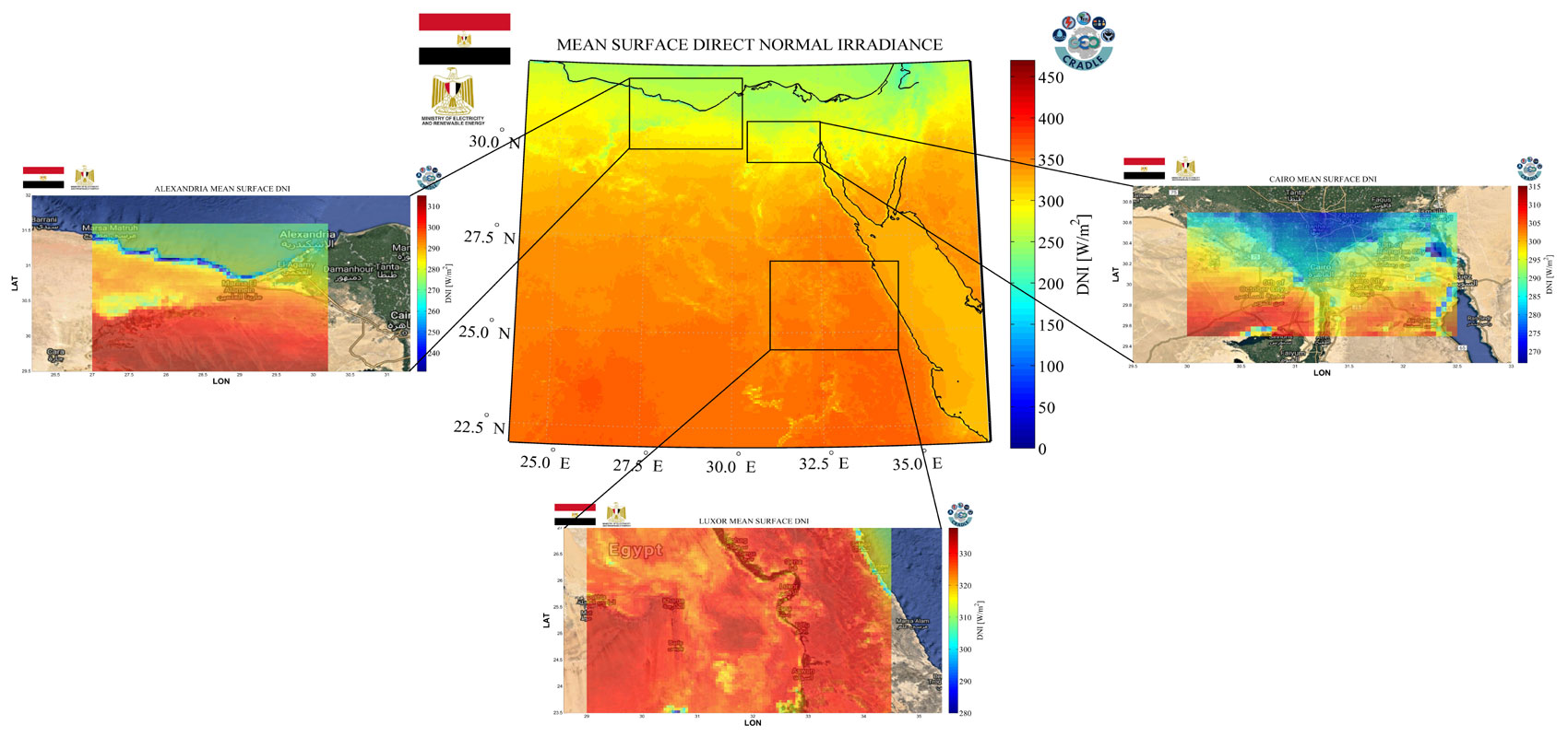
CLIMATOLOGY
The mean monthly solar energy maps are based on a 15-year climatology of the Direct Normal and Global Horizontal Irradiances (DNI and GHI respectively), while the spatial resolution is almost 5 km. The solar atlas maps were produced for Egypt and for specific locations (greater area of Alexandria, Cairo, Luxor and Aswan). The climatological radiation data are from the EUMETSAT's Satellite Application Facility on Climate Monitoring (CM SAF)
CONTACT
The services of this website are appropriate for:
1-Location studies for the placement of CSP and PV installations
2-Large-scale and precise solar energy calculations to assist Public Authorities in energy planning policy
3-Supporting the work of various scientific communities
4-Provision of specialized data of high spectral precision for private and public sectors dealing with health protection (UV-Index, Vitamin D effective dose, etc.), energy consumption and solar energy exploitation
For further information contact:
PARTNERS


© This website has been implemented in the framework of the GEO-CRADLE project(http://geocradle.eu/)