
Page 6 - Mauritius REPORT
P. 6
Republic of Mauritius
Introduction
Mauritius actively employs national and international law to mitigate some of the challenges the
country faces while also ensuring that they benefit and grow from the marine and coastal resources.
Country Profile
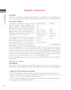
Key country indicators
The Republic of Mauritius is made up of the Population (2018) 1,265,303
islands of Mauritius, Rodrigus, Agalega, Saint GDP
The Republic of Mauritius
Brandon, Agalega, Tromelin, Diego Garcia,
and Cargados Carajos and Chago Archipelago GNI
according to Article 111 of the Constitution of Total land area 2000 km 2
Mauritius (ROM, 1968). Mainland Mauritius is Length of coastline 332 km
the largest and most populated of the islands. The 2
population in 2018 was 1,265,303 Exclusive Economic Zone 2.3 million km
Continental shelf 396,000 km 2
The World Bank estimates Mauritius’s total land Mangrove 1.2 km 2
2
area at 2000 km , with a coastline of 322 km.
Mainland Mauritius covers an area of 1,865 km Coral reef
2
and is volcanic in nature. The coastline has a Marine protected area
243 km shallow lagoon area which makes it an
2
Source: (World Bank, 2017)
ideal location for tourism, such as boating and
snorkeling (Ragoonaden, 1997). The beach width varies from a few meters (in eastern and southern
regions) to 25m (in the north-eastern regions). Mauritius has sovereign rights over an Exclusive
Economic Zone (EEZ) and continental shelf of 2.3 million km and 396,000 km respectively (ROM).
2
2
Despite the vast extent of EEZ, almost 99 per cent remains unexplored (MAIFS, 2017). About 0.3
per cent of Mauritius’ territorial waters is Marine Protected Areas. The country’s total coral reef and
mangrove area are estimated at 870 km and 1.2 km (World Bank, 2017).
2
2
https://sustainabledevelopment.un.org/content/documents/11803Official-List-of-Proposed-SDG-
Indicators.pdf
Ecosystems management
The challenge
The outcomes of human activity such as population growth, urban development, waste disposal are
leading to environmental degradation, threatening the wellbeing of the marine and coastal ecosystems.
Target 14.2: Protect and restore ecosystems
UN definition: By 2020, sustainably manage and protect marine and coastal ecosystems to avoid
significant adverse impacts, including by strengthening their resilience, and take action for their
restoration in order to achieve healthy and productive oceans
Status: The proportion of Mauritius’ national exclusive economic zones managed using ecosystem-
based approaches is 49.6439 (UN Stats 2019)
6